■READING THE WATER, PART ONE, INTRODUCTION.(川を読む。序論)
No, this blog post is not about a magical river flowing from the headwaters of the Unicorn Mountains, and if you learn it’s secret language, you could read a story about a magical voyage long ago; rather, it is about knowing where fish can be located within a stream based on observable hydrological and structural characteristics.
このブログはUnicorn Mountainから流れ出している不思議な川について投稿しているわけではない。もし君がそれは秘密の言葉を学んでいるなら、昔の魔法の航海(magical voyage)の物語を読めるでしょう。この投稿は、むしろ観察できる水文(水の循環、移動)とその地形上の特徴に基づいて「川の中のどこに魚がいるか」を知ろうと言うものです。
As a child learning to fly fish, I was always told that being able to “read the water” is an essential skill for an angler's success. At the very least, understanding the fluid dynamics and structural characteristics of a stream can lend the angler the ability to find fish within a given location.
フライフィッシングを練習している子供のように「川を読む」能力が釣りの成功に不可欠な技術だと、ボクは常々話している。少なくとも、川の流れの流体力学とその地形上の特徴を理解することが、川辺で魚を見つける能力を釣り人にもたらすのだ。
From the age of ten onward, I dedicated myself to learning about where fish like to dwell within the dynamic world of moving water. I recall sitting in the passenger seat on long drives into the mountains looking at the streams along the road. “Look at that spot; that ought to be a good spot to fish,” I would say, when I identified what looked like a fishy looking fluvial characteristic. Sometimes, I would beg my parents to stop and let me out so that I could at least make a couple of casts in another fishy looking spot just to see what would happen. I always brought my fly rod with me on family road trips into the mountains with an optimistic hope that a lunch spot would afford me at least a few minutes to practice my fly fishing skills.
ボクは10代のころから川の流れの動的世界の中で、魚の好む場所について理解することに没頭してきた。山岳地帯へ長距離ドライブで出かけ、道路添いを流れる川を助手席から見ていたことを思い出す。「あそこを見て!釣れそうだよ」魚が居そうな場所を見つけるとそう言ったもんさ。ときどき、両親に車を止めてもらって、「あの釣れそうな場所で、何が起きるか数回キャストしてみたいから降ろして!」と頼んだものさ。家族で山岳地帯へ旅行するときはいつも楽観的に期待しながらフライロッド持って行った。ランチのとき、フライキャスティングの練習を少なくとも2・3分間した。When I was 42, I left my previous two careers in favor of pursuing my fisheries biology degree. I spent a summer working as a stream surveyor for the United States Forest Service. Because I had so much previous experience being able to locate fish in a stream environment, I was tasked with conducting stream snorkeling surveys, looking for coho and bull trout. I later learned more scientific terms for defining different stream classifications and hydrological features both in school and on the job. I now have a language I can speak for describing fluvial fish habitat.
42歳になったとき、水産生物学の学位取得に専念するために前の2つの仕事を辞め、夏はアメリカ合衆国森林局の河川調査官として働いた。それまでに河川で魚のいる場所を見つける長い経験があったので、そこではコーホとイワナを探しながら、河川でシュノーケリング調査する仕事に就いた。その後、学校と仕事の両方で、川のいろいろな流れの分類と水理の特徴を定義する科学的用語をたくさん学んだ。I was scouting new water today while taking a bank side stroll with my wife. As we walked along I mapped out this rather featureless beat I might add to my guiding options. We pressed on hoping to find some water with more definition that would appeal to my fish finding senses. I saw an angler working some completely nondescript water, water that I wouldn’t even string up a rod to fish (see my post about laminar flows). To me, it would be like fishing on the moon. There would likely be fish present in that location, but there is nothing unique about the structure to give one a visual clue as to fish location. I then realized that the angler I observed might not be skilled at reading the water, or his skill set may not be strong enough to confidently fish the water with more defined structure and dynamic currents, like those located just upstream from him.
今日は、妻と一緒に土手をぶらぶら歩きながら、新しい川を偵察してきた。ボクたちは歩きながら、ガイドのオプションに加えようとしていた平凡な釣り場(beat)より、ここを地図に書き込んだ。魚を見つけ出す能力をアピールできるような表現で、ある水域を調査したいと迫った。私はまったく平凡な流れで釣りをしている人を見かけた。そこは、私が釣りたいとさえ思わなかった流れだった。私には、月で釣りしているように思えた。魚がいそうだったが、そこには釣るための視覚的手がかりになるようなユニークな特徴は何も無かった。それで、私が見た釣り人は「流れを読む」ことに慣れていない、あるいは彼の上流側の流れのように、より明確な渓相の流れを自信を持って釣るのには、彼の技術は十分でない、と思った。I often see anglers fishing in water I rarely stop to explore. I used to wonder if these people knew something that I didn't, or if they just were not educated enough about reading the water? I know, after having snorkeled in plenty of water like the nondescript boulder flats I see anglers frequently fishing, that the fish are few and far between in those locations. Perhaps they are happy with the occasional fish that they work so very hard to catch?
ボクが滅多に立ち止まらない川の流れで、ときどき釣人を見掛ける。ボクの知らない何かを、彼らは知っているに違いない、あるいは彼らは川を読めない、と思っていた。ボクは、釣人を見かけた何の変哲も無い幅広い平瀬のような水域をたくさん潜水調査してきている。そのような場所では、魚はごく稀にしかいない、ことを知った。恐らく、彼らは苦労して釣ることで満足なんだろう?
It would take me a hundred pages to describe the preferred trout habitat and the techniques to fish each and every one of them. To ease your pain, I will parse this information for you into smaller chunks you can read in small doses. Over the course of the summer we will define specific hydrological features and how fish utilize them. I will try to include as many videos and illustrations as possible, so that I can steer you out of the barren cobble flats with laminar flow into more exciting water full of fish.
魚を釣るための技術と鱒が好む場所を書き表すためには、数百ページが必要だ。君の苦しさを和らげ、僅かな努力で読めるように、この情報をかみ砕いてあげよう。夏季コースではある特定の水理学上の特徴を定義し、魚がそれらをどのように利用するかを学ぶ。ボクはできるだけたくさんのビデオとイラストを使う。これで、さざ波ができる小石からなる不毛の平瀬から、魚が一杯いるワクワクする荒瀬へ、君たちを向かわせることができる。
I will use a specific language to describe rivers and streams, not only when I am describing fluvial characteristics but also when I discuss benthic macroinvertebrate distributions within a watershed (yawn). Yes, that will be another day.
ボクは川とその流れを表すために川の特徴を説明するときだけでなく、分水嶺内の川底の大型無脊椎動物(macroinvertebrate)の分布について論じるときにも、特別な言葉を使います。でも、それはまたの機会に。
Fluvial: Fluvial is a term used in geography and geology to refer to the processes associated with rivers and streams and the deposits and land forms created by them.
河川の(形):Fluvialは川の流れに関係した過程と川の流れによって作られた堆積物と陸の形を示すために使われる地理学と地質学上の用語です。
Benthic: The benthic zone is the ecological region at the lowest level of a body of water such as an ocean or a lake, including the sediment surface and some sub-surface layers.
底生(形):底生ゾーンとは、湖や海のようなその本体の底部における生態系のゾーンのことで、堆積物表面と表面下層も含んでいる。
Thalweg: is a line drawn to join the lowest points along the entire length of a stream bed or valley in its downward slope, defining its deepest channel -- often having the deepest, heaviest current.
谷線(谷みち):下り坂の谷、または川底の全長に沿う最低位の点を繫ぐために引かれる線で、最急な溝を定義し、ときどき最も深く、重い流れになる。
Laminar Flow: In fluid dynamics, laminar flow (or streamline flow) occurs when a fluid flows in parallel layers, with no disruption between the layers. Observed as smooth even current from bank to bank.
層流:流体学において、層流(流川流)は層間に乱れが無く、平行した層の状態で流体が流れるときに生じる。川岸から川岸へスムーズで平坦な水流として観測される。
Substrate: The composition of the bottom of the stream from sand, silt, clay to stones, cobble and boulders.
素地:砂、シルト、粘土から石、小石、大石までの川底の構成のこと。
Embeddedness: The degree to which fine sediments surround coarse substrates on the surface of a stream bed is referred to as embeddedness.
推積:川底の表面において粒度の大きい素地の周辺のキメの細かな沈殿物の度合いをembeddednessと言う。
Riffle: A riffle is a shallow section of a stream or river with rapid current and a surface broken by gravel, rubble or boulders. Riffles are instrumental in the formation of meanders, with deeper pools forming alternately.
Riffle(早瀬):Riffleとは水流が速く、川底が砂利、小石、大石でできていて、水面が乱れる川の区間です。Rifflesは形成されるより深いプールのことで、一方で曲がり(meanders)形成の助けになっている。
Pool: in hydrology, is a stretch of a river or stream in which the water depth is above average and the water velocity is quite below average. A pool must extend from bank to bank. A side pool does not extend from bank to bank but to the side with faster water defining one side if the pool. A side pool will generally have a current seam and back eddy characteristics.
Pool(プール):Poolは水文学では川の直線部分で、水深が平均以上、流速は平均よりかなり低い。プールは川幅一杯に広がっている。
Current Seam: the parallel junction between two distinct current speeds as they slip past each other.
水流の継ぎ目(潮目):2つの流れが互いにすれ違って動くとき、2つの異なった水流の速度間にできる平行な接合面のこと。
Foam Line: Where bubbles gather in specific patterns along the length of current as defined by that current.
Foam Line(泡群のライン):その水流で輪郭が形成されるように、泡が流れに沿ってある特定の紋様で集まる場所のこと。
Pocket Water or Pocket Pools: Small bank side pools outside of the Thalweg that are defined by and protected by boulders that cannot be technically defined as a pool.
Pocket Water(ポケットになった水域):谷線(thalweg)から外れた小さな川岸際のpoolのことで、技術的に1つのpoolとして定義できな。Pocket waterは大きな石で形成されていて、また守られている。
Wetted Width: the width of a body of water as described by the current water level.
川幅(法面が濡れている部分の幅):水流レベルによって記述される川本体の幅。
Up Next: Current seams and bubble lines. What do they mean?
Up Next:水流の境界と線状の泡。どう言う意味?
■READING THE WATER PT 2. SEAMS AND BUBBLE LINES(川を読む2。境目と線状の泡)
There are a few basic visual clues one can learn to observe about streams in order to narrow the window of where fish are likely holding, especially on big rivers where fish could be anywhere; especially if you don't know how to dissect large parcels of water into smaller subsections. One of the most obvious and often overlooked indicators of likely fish locations are the bubble lines or bubble zones. Bubble lines occur where the current gathers together usually as a result of some instream structure funneling the surface bubbles into predictable locations which also funnels food into a small area making feeding easier for fish, thus expending fewer calories in an effort to feed. Instead of having to swim all over the place looking for food, a fish can hold in a preferred spot where the food is funneled directly to them. Current seams can also define the location of a bubble line or at least prove a location that can also funnel food into a narrow band. Though typically a bubble line is caused by underwater structure. Structure that gives fish a safe location in which to hold and feed. Usually, you will find current seams and bubble lines very near each other,
魚がどこにでも居そうな大きな川では、その範囲を狭めるために、特に君が水域がどのように小さく分割しているか知らないなら、川について観察するための視覚的手がかりが2・3つある。魚の居そうな場所を示す明確であるが見落としがちな指標の1つはBubble lines(線状の泡)か、水泡エリアだ。それは通常、複数の流れが一緒になったときに、水面の泡を予測できる場所へと巻き込む川の内部構造の結果である。また、それはエサを魚が簡単に採餌できる狭いエリアに巻き込んでいる。そこでは、魚は採餌のためのエネルギーをほとんど使っていない。魚はエサを探すためにあっちこっち泳ぐ代わりに、エサが直接じょうご状に集まってくるお気に入りの場所に定位しているのだ。流れの境目(シーム)はまた泡の線(Bubble line)の位置を明らかにし、または少なくとも狭い範囲にエサを集める位置をハッキリ示している。一般に線状の泡は水中の構造によって生じる。その構造は魚を定位させ、安全に採餌できる場所となる。通常、流れの潮目と線状の泡はお互いの近くで見つけることができるでしょう。
In the images below, I illustrate some of the most obvious instances of water that contains bubble lines, current seams and structure. If you stumble upon a small section of water that contains all three, take a moment to analyze what you are looking at. Chances are there may be a feeding fish.
下の写真は、線状の泡、流れの境目、川底を含んだ川の流れの最も分かりやすい例だ。もし君が3つすべてを含む小さな水域に出くわしたなら、それを分析するために少し時間を取りなさい。採餌している魚がいるかもしれない。
In figure 1. You can see several prime structures you should look for when searching streams for likely trout holding water. There is an obvious current seam defining the slow and fast water, obvious underwater structure fish can use to hide near and a bubble line funneling food into the best possible holding spot. Can you identify where the fish should be in this picture ?
図1では、君が探すべき、鱒が定位していそうな川の基本川底を見ることができる。そこには速い流れと遅い流れをハッキリさせる明らなか水流の境目、魚がすぐ隠れることができるハッキリした水の中の川底、そしてベストな魚の定位場所へとエサを引き込む線状の泡が存在している。君はこの写真のどこに魚が居るか、分かるかい?
Figure 1. Typical Grade A trout structure. It has cover from above, A strong bubble line funneling food near structure with a quick escape route next heavy fast current.
図1 グレードAの鱒が定位する典型的川底。上からカバーがあり、隣の速い流れに素早く避難できる川底、その近くにはエサを巻き込む強い線状の泡がある。

Figure 2. Current structure defined between current seams and foam lines or bubble zone.
図2 潮目と線状の泡の境目間の流れの構造

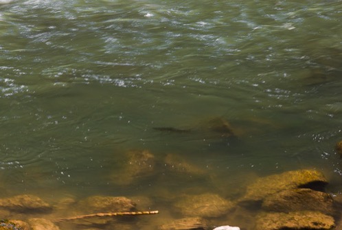
Figure 3. A trout revealing its exact location
図3 居場所を見せる鱒
■READING THE WATER PT3. DECIPHERING LAMINAR FLOWS(川を読み3.層流を読み取る)
Not every river you fish will feature endless arrays of perfect pockets, pools, seams and structure in which to easily locate fish. Sometimes, we have to find fish in water that has less distinct characteristics. Rather than waste time blindly casting to empty water, possibly putting down fish with our efforts, stop and take time to observe the surface characteristics of the flow.
すべての川というわけでないが、たくさんの完璧なポケット、プール、潮目、そして川底が重要であり、そこでは簡単に魚を見つけることができる。ときどき、特徴が不明瞭な川で魚を見つけなければならない場合がある。魚の居ない川に向かってキャストして時間を無駄に消費するよりも、できるだけじっと魚を見下しながら、立ち止まって川の流れの水面の特徴を観測することに時間を使え。
Laminar flow can be the most enigmatic water to decipher. It is water that flows at an even speed from top to bottom bank to bank. I normally walk by water that exhibits no obvious structure in which to target my effort. Smooth even currents from bank to bank merely bumping over the rubble is akin to fishing on the moon. I know fish are present, often seeing rises out in the nondescript waterscape, but fishing this water requires more time and effort than casting to fish around obvious structure.
層流(Laminar)は川の流れを読むための、最も謎めいた(enigmatic)水域だ。それは、川岸沿いの流れの表層から川底まで、一定の速度で流れている水域のことだ。普通、ボクは川底がまったく不鮮明な水域近くまで歩き、そこで頑張る。泡が川底の小石を越えて揺れながら、岸幅一杯に広がったスムーズで均一な流れは、月での釣りと同じだ(釣れそうもない?)。特徴の無い水辺で魚がライズするのを見ながら、ボクは魚がいることは分かる。でも、そこで釣るためには、川底がハッキリした場所の周辺でキャストするよりも、もっと時間と努力を必要とする。
If you do chance upon a feeding fish in a section of river that is laminar in structure, spend some time observing where that fish is located. Even without the telltale signs of current seams, the location of drifting insects and fish are not left to chance. There is a structure at work that the fish use to thier advantage.
もし君が層流の水域で採餌する魚に賭けてみるのなら、魚がどこにいるか観察することに時間を割け。流れの境目が分かるサインがなくても、水面を漂流する虫の位置と魚が、チャンスをくれる。そこは魚に有利な川底をしているのだ。
Fish will use whatever structure is available to them within the limited confines of a river. Sometimes we must look at less than obvious structures in the laminar sections of water. When looking at laminar flow, observe the structure of the river bottom and speed of the current. If the substrate consists of only sand, silt or very small cobble, with a flow that is walking speed or faster, you are better served moving along in search of something else. However, if you find laminar walking speed flow with a substrate that consists of bowling ball sized cobble you are in luck. You have found water that may contain fish. Small boulders create micro vortices that can hold a fish in the current, so the fish spends very little effort in maintaining its position. Deschutes River steelheaders know this when they fish those classic named mile long runs.
魚は、川のある特定の範囲で利用できる「川底」なら何でも使っている。ときどき、層流区間でハッキリしない川底にしっかり目を向けなければならない。層流を調べるとき、川底の構造と水流の速度を観察しなさい。もし、川底が砂、小石、泥のみから成っていて、流速が歩行速度程度か、それより少し速いなら他を探した方が良いだろう。でも、もしボーリング玉大の石からなる川底で、歩行者速度の層流を見つけたなら、君は幸運だ。魚のいる水域を見つけたことになる。小型の丸石は、魚が水流でその身を定位できる小さな渦流を作る。それで魚は簡単に自分の位置を維持可能になる。Deschutes川のスティールヘッダーは、彼らが古典的な名前の「マイルの流れ」で釣るとき、このことを知っている。

Figure 1. Laminar Flow(層流)
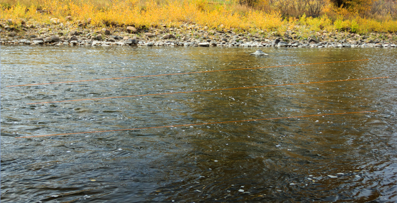
Before you wade into the river and start casting with the usual routine of starting in close working your way out in a clockwork shotgun fashion, take time to look at the surface of the water and try and find the “lanes” that do exist. Lanes are the micro seams that slip past each other funneling everything that drifts downstream into narrow bands. The best way to find the lanes is to find the bubbles. Are the bubbles accumulating in a concentrated area? If so you have found your lane. It may take some time to train your eye to look for a higher concentration of bubbles gathering in an inch wide seam amidst an even dispersion of bubbles, but when you do, you have found your area of concentrated effort. Fish will be located within close proximity of these micro seams in order to easily slip away from thier vortex and inspect a likely morsel.
川をウェ−ディングし、何時ものように自分のやり方で時計回りにキャストを始める前に、水面を調べる時間を取って、そのLanes(レーン)を見つけなさい。レーンは微細な潮目で、下流の狭い範囲へ漂流物すべて通過させる。レーンを見つけるための最良の方法は、泡を見つけることです。あるエリアに泡が集積しているか?もしそうなら、君は自分のレーンを見つけていることになる。散らばった泡の中で1インチ幅の潮目に集まってくる高濃度の泡を見つけるためには、目を訓練する時間が必要だ。でも君がそのようにしたときは、もう集中して練習する場所を見つけているのだ。魚は渦流からこっそり離れて、エサになるものを調べるために、それらの微細な潮目の近くに潜んでいるであろう。

Figure 2. Lanes are revealed as white lines caused by the accumulation of bubbles in concentrated micro seams.
(密集した境目に蓄積した泡によって、白線状にレーンが現れている。)

Figure 3. Orange lines indicate the location of the lanes within a Laminar flow profile.
(図3 オレンジ色の線は層流内のレーンの位置を示している)
In the images above, I have used the tools of photography to illustrate where micro seams actually occur. In figure 1, we see a general random dispersion of bubbles on the surface in a section of laminar flow over bowling ball sized substrate. In figure 2, I exposed the image longer to blur the lines and now you can see the micro lanes as faint white stripes, so that you will know better where to concentrate your efforts.
上の写真では実際に微細な境目がどこに生じるかを示するために、写真ツールを使っている。図1では、ボウリング玉サイズの川底の上の層流の区間に、水面に乱雑な泡の消散が見える。図2では、線状の泡をぼかすために少し長く露光した。それで微かな白のストライプで微細なレーンを見ることができる。釣りのとき、どこを攻めれば良いかがより明確になっている。

Figure 4. Can you see it now?(図4 君は分かるかい?)
■FISHING THE EDGES - READING THE WATER PT IV(川を読む4。縁を釣る)
When I guide with guests who wish to learn more about fly fishing or to sharpen their skills, I teach them two mantras: fish the edges & the foam is home. Finding fish is the most important part in fishing. However, you would be amazed at how many times I show up to a crowded beat on a river and see people ignoring the prime water, and instead, fishing water because they are observing an occasional fish feeding here and there. They are fishing with their eyes and not their river reading skills. Knowing how to find hidden fish in heavy water can yield big results.
「フライフィッシングを学びたい」、「もっとうまくなりたい」と思っている客をガイドするとき、ボクは2つの呪文(マントラ)を教える。「縁(Edges)を釣れ」と「泡沫(Foam)はホームだ」ということだ。魚を見つけることは、釣りで最も重要なことだ。でも、ボクが混み合った釣場(beat)に出かけて、一級の釣り場を無視し、代わりに、ときどき魚が採餌するのを目撃した場所で人々が釣っているのを目撃すると聞けば、君はその回数に驚くことだろう。彼らは自分の目を信じて釣りをしているのであって「川を読む」知識を信用していない。流れの速い川で潜んでいる魚を見つける方法を知ることが、釣りの成功に繋がる。
Recently, I was on a popular beat of the Yampa River in downtown Steamboat Springs. I have a favorite spot that conceals a lot of very nice fish. My river log will tell you my success on the Yampa and much of it can be correlated to this particular spot among just a handful. The froggy pool above me had two anglers swinging patterns to no avail and the pool below me was occupied, as it usually is on a daily basis. Yet, right smack in the middle of the river lays my favorite spot hidden in plain sight. I wade across to begin my approach while thinking to myself that surely, someone had to have pounded this spot and my efforts might be to no avail. I made my second cast and hooked and landed a nice 18" brown. I hooked and landed a few more fish and broke off a large gator rolling rainbow. I know that this spot does get fished as I have removed many flies that have broken off in the snouts of fish here. Perhaps these fish had been hooked elsewhere and sought refuge in this rarely fished spot?
最近、Streamboat SpringsのYampa川(Colodaro州)の人気の釣場へ行ってきた。いいサイズの魚がたくさんいる秘密の場所を知っている。ボクの釣り記録から、君はYampa川の釣り成功体験を学べる。その大半は特定の釣場に関係している。ボクの上流側の蛙の多いプールに、二人の釣れていない釣人がいて、下流側のプールには毎日先客がいた。川の中流は、まだ小型の船がよく見える状態だった。きっと誰かがこのスポットを叩いていて、釣れないだろうと思いながら、ウェーディングでスポットに接近し始めた。二回目のキャストでヒットさせた。18インチのブラウン・トラウトだった。更に数匹を追加し、体をローリングされて大型のニジマスを取り逃がした。魚の鼻先で取り逃がしたたくさんのフライを取り除きながら、このスポットで釣れることは分かっている。恐らく、これらの魚は他の場所でも釣られていて、この滅多に釣られないスポットで、魚は隠れ場所を探してきたのだろう。
What makes that particular spot on the Yampa and other similar spots unique is that it contains well defined edges and foam lines. An edge is where differing current speeds slip past each other and are often bordered on one or both sides by heavy water. Steelheading anglers know this as a current seam and that is where steelhead like to hold or travel along. Edges can also be defined by channel morphology such as gravel bars and drop offs or converging currents. In short, it gives fish structure both above and below the water surface.
Yampa川のある特別なスポットと他の場所の似たスポットをユニークなものにしているものは、明瞭な縁と線状の泡がある点だ。「縁」は水流の異なる速度がお互いに通り抜ける場所で、重い流れによって片側か両側に縁ができる。スティールヘッダーはこれを「水流のシーム」と言い、スティールヘッドはここに留まったり、これに沿った遡上を好むことをよく知っている。また縁は、砂利の洲(gravel bars)とDrop offs(川底の落差)、または合流する流れとして、流路形態によって定義されている。要するに、水面の上と下の両方で、魚に地形(隠れ場)を与えることになる。
Fish need three conditions for basic survival. Cover from above, a steady predictable food source drifting within close proximity and respite from the current. Edges usually provide all three of these conditions. If you find edges that contain a bubble line or a foam line you have found an ideal location to probe with a tactical nymph. Bubble lines are a clear indication of a current feature that funnels everything drifting downstream into a reliable path and if one is located near an edge you have eliminated a lot of guesswork. You can read about foam lines here.
魚は生きていくために基本的に(サバイバル)、3つの条件が必要だ。1)上からのカバー、2)近くを漂う安定して予想できるエサ、そして3)水流に対する休息だ。縁(Edge)はこの3つ条件をすべて与えてくれる。もし、君が線状の泡(bubble line, foam line)がある縁を見つけたのなら、戦術的ニンフを試す理想的な場所を見つけたことになる。線状の泡は水流の特徴を表す明確な指標で、下流へ流れるすべてのモノはその信頼できる経路に収斂する。もし君が縁近にいるのなら、たくさんの当てずっぽうを取り除いてしまっていることになる。ここで、君は線状の泡について読むことができる。
The image below is perhaps one of the best examples of what a very "edgy & foamy" section of river can look like. On the left is a gravel bar forming an edge with a heavy section of current forming the other edge. A foam raft near the top provides cover for fish and the bubble lines gives us a clue that there is a food path for the fish. This pool also provides cover from above and bowling ball sized boulders on the bottom providing a buffer from the current. You can see the size of the boulders middle upper right. I watched two anglers fish this pool before I reached it and I managed to catch a few more fish out of it before calling it a day.
下の写真は、おそらく、非常にEdgyでFoamyな河川区間の良い例であろう。左岸(上が上流で、上流から下流を眺めた場合の左側。つまり右側)に、他の縁を形成する荒い流れのある縁を形成する砂利の中洲がある。頂上付近の白泡の浮遊物は魚のカバーになり、線状の泡はエサが流れる経路の手がかりになる。このプールには上流にカバー、川底に水流の緩衝となるボーリング玉大の石もある。右の中央部の川底にボルダーサイズの石が見える。そのプールに到着する前に、2人の釣人が釣っているのを見ていて、 一日が終わる前に(before calling it a day)、どうにか数匹釣ることができた。
GRAVEL BARS(砂利の中洲)
Green areas are the prime spots within the confines of this edges to pay special attention to. Don't forget to fish both sides of a heavy current edge and any pockets whereabouts additional fish might be found.
緑色のエリアは特別に注意すべき縁の第一級スポットだ。急流の縁と魚が居そうなポケットの両方で釣ることを忘れるな。
HYDRAULIC EDGES(水流の縁)
This pool is another example of an edge. Here, converging currents create a hydraulic edge thus defining a feeding lane and cover from above. Fish will hold very near the fast water slipping away to intercept anything edible that might be coming down the pipeline. There is a special spot near the top center of this riffle where the fish are protected on both sides from current cover allowing them to move either left or right in search of food. Can you find the sweet spot?
このプールは別の縁の例である。流れが合流し、採餌レーンと上側からのカバーを明確にする縁を作っている。魚はこの流れに乗って流れてくるどんなエサでも捕食できるように、スーッと流れ去る速い流れ近くに定位している。早瀬の瀬頭の中央近くに特別なスポットがあって、そこでは魚がエサを探しながら左か右に移動するために、流れのカバーによって魚の両側が守られている。君にはその最高のスポットが分かるかい?
It's worth attempting to fish the near side of this current edge however, heavy angling pressure will likely cause the fish to concentrate in the water seeing less pressure. I landed a 21" rainbow and 18" brown rainbow out of the green section of this beat.
この縁近くで釣りする価値がある。しかし、釣り人達のプレッシャーが、プレッシャーの少ない水域に魚たちを追いやるだろう。ボクはこの緑色のセクションで21インチのニジマスと18インチのブラインと釣り上げた。


0 件のコメント:
コメントを投稿